Tips to Prepare for Travel Photography
Next month I am going to Istanbul, Turkey. I have not been taking a lot of pictures this winter so it will be the perfect opportunity to pick up my camera. When I travel somewhere for the first time, I like to plan ahead for both visits and photography. There is a lot of tools available for that on Internet. Let me share a few of my favorites.
Google Search
It's the most obvious. If you google "things to do in Istanbul", "Istanbul sightseeing", "Istanbul must-dos" or "best of Istanbul", you will quickly get a pretty good idea of the most famous tourist attractions in the city and the liveliest neighborhoods. I usually make a list of these results on my iPhone with some kind of star rating.
GPS
I use an iPhone app named MotionX GPS. It is great because it allows me to cache maps so that I can actually use the GPS while I am off-line abroad. I save the location not only of the top attractions but also of my hotel. Think about it, in a country where you do not speak the language, having the ability to check that your cab from the airport is going in the general direction of your hotel is very comforting. Some people find the use of a GPS constraining. I actually think it is liberating. You can improvise your itinerary, going from one sight to the next using the GPS to link the dots. Of course you can miss a lot of the atmosphere of the place if you spend all your time looking at your phone. But if you have some sense of direction, there is a middle ground which will probably get you some memorable, serendipitous sights because you were not worried to get lost. Now I even enjoy getting lost!
Guide Book
I have to admit that I still buy a guide book. Most of the time it is just to get a good paper map as a backup of my phone's GPS (more precisely to my phone's battery when using the GPS). That's why I pay special attention to the level of details in the street names (are most streets named or only the main streets?). Public transportation is also very important (subway stations, bus stops etc.). Finally make sure that the maps have a scale to get an idea of distances.
Flickr
Now let's focus more on the photography side. Many photographers tag or even geotag their pictures on the net. Flickr is a great resource to find pictures of the places you are going to visit. I often use it as an inspiration. I also use it to get an idea of what the monuments really look like, what are their surroundings and when is the best time of day to photograph it. I also check this site for the sunrise, sunset and moon phase.
Google Earth
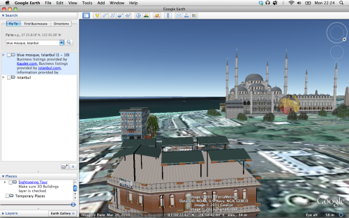
When I see a really great picture on Flickr, I try to deconstruct it: to find out at what time the photo was taken and where from. That's where Google Earth is particularly useful. Let's take for example this picture of the Blue Mosque by Oberazzi.
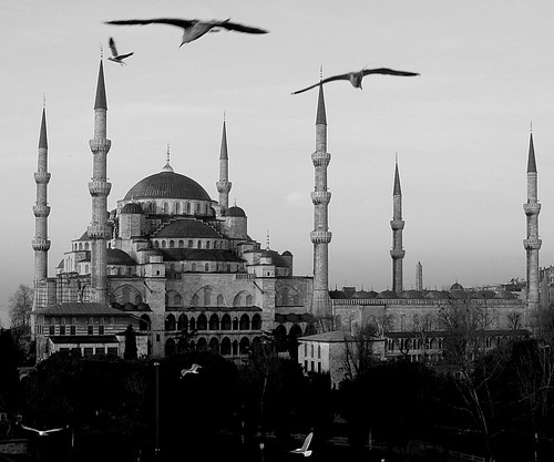
The Mosque is wonderfully framed. I was really curious to know where that picture was taken from. So I fired up Google Earth and after a little bit of virtual flying around, I figured it out: the picture was probably taken from the rooftop of the Seven Hills hotel. Nice tip Google Earth!
I hope by now I have convinced you that Internet has a wealth of tools to offer to plan your next photography trip. Enjoy your next trip and feel free to leave more tips in the comments.
Short URL for this post: http://lepl.us/14